To view this movie, click on the images.
Download: Southern California Transverse Ranges Rotaion movie and related images (18 MB)
|
|
|
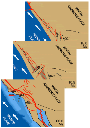
Shows a model for the tectonic evolution of southern California and northern Baja California, from 20 million years ago to present, approximately depicting the rotation of the Transverse Ranges block and the breakup of the continental shelf to form the California borderland. Download package includes the animation and supporting map images of the present day Transverse Ranges physiography, the proposed rotation trajectory, and the California borderlands and offshore islands. |
|
|
|
To view this movie, click on the images. |
|
|
|
Comments on this and all of the materials offered on this site are welcomed: atwater@geol.ucsb.edu |