To view this movie, click on the images.
Northeast Pacific and Western North American |
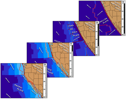
Shows the plate tectonic history of the northeast Pacific and western
North America, 38 million years ago to Present (stable North America held
fixed). Includes the breakup and piecewise subduction of the Farallon plate
and the consequent development of the San Andreas plate boundary. |
|
|
|
To view this movie, click on the images. |
Present Situation (last frame of movie). At Present the Pacific Plate fills most of the northeast Pacific Ocean basin with only the small Juan de Fuca and Cocos plates remaining from the previous configuration. The various shades of blue show the ages of the sea floor, as deduced from marine magnetic anomalies. The Pacific plate is moving northwest past North America. It has captured some slivers of the continental edge and is carrying them northwestward toward Alaska. Thus, the present Pacific-North America plate boundary lies within the continent, along the San Andreas fault system. It is connected to other plate boundaries at three-plate triple junctions, the so-called Mendocino and Rivera triple junctions; the locations and motions of these triple junctions help determine the on-shore geology in each time and place. Early Cenozoic Situation, 38 million years ago (first frame of movie). In the early Cenozoic, 40 Million Years Ago, other oceanic plates lay between the Pacific and North American plates. They were spreading away from the Pacific plate and subducting beneath the rim of the continent. • East Pacific Rise Migration. Coming forward in time, the eastern edge of the Pacific plate moved steadily northeastward as new sea floor was accreted by sea floor spreading. Eventually, the spreading center itself reached the subduction zone and the intervening plate was destroyed. The Pacific plate began to break off pieces of North America and carry them along the coast, creating the San Andreas-Gulf of California plate boundary inside the continent. • Triple Junction Evolution. Watch the motions of the triple junctions. The Mendocino triple junction migrated steadily up the coast, attached to the Mendocino fracture zone on the Pacific plate. The Rivera triple junction hovered near the southern California borderland then, about 12 million years ago, when sea-floor spreading and subduction ceased off Baja California, it jumped to its modern position at the mouth of the Gulf of California. • San Andreas System Evolution. The past evolution of the San Andreas fault system occurred in two stage process. First the Salinian and borderland pieces of the continent were gradually transferred to the Pacific plate, later Baja California was transferred. A third stage has begun: the Sierra Nevada/Great Valley block is in the early stages of being transferred and carried away. • Pacific Plate Motion. Watch the motion of the Pacific plate. It continually moved off to the northwest. • Basin and Range Expansion. Now watch what happened to the interior
of North America. In the early Cenozoic, western North America was much narrower.
(Check out narrow Nevada!) During the late Cenozoic it expanded, forming the Basin
and Range province. This occurred during the time that the Pacific plate was pulling
the rim of the continent away to the northwest, perhaps causing the expansion or,
more likely, just making room for it. (It was already elevated, hot and weak, ready
to fall apart given the chance. |
|
Comments on this and all of the animations
offered on this site are welcomed: atwater@geol.ucsb.edu |