|
Made by Tanya Atwater from the 1990 computer collections
of the Lamont-Doherty Earth Observatory.
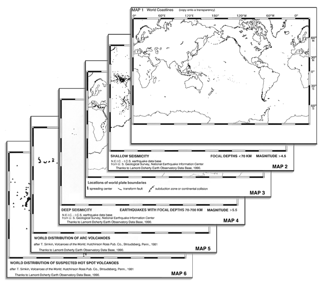
This is a set of 6 world maps that I compiled to help my
students explore the distributions of earthquakes and volcanoes
and their relationships to world plate boundaries. They show
that lines of shallow earthquakes delineate many of the plate
boundaries, that bands of deeper earthquakes and arc volcanoes
locate the subduction zones, and that the locations of hot
spot volcanoes are, for the most part, independent of the
surface plate geometries, suggesting sources in the deeper
mantle.
For each group of 3-4 students, I create a stack with Map 1
xeroxed onto a transparency and Maps 2-6 on paper. IMPORTANT:
Do all the xeroxing at one time, both transparencies and paper maps;
copy machines tend to drift in scale and you want them all
to be exactly the same scale so that they overlay well.
The "Instructions" document describes the map exercise that
I created for my classes. Use this or make up your own exercise.
The maps include:
1. coastlines (to be used as a transparent overlay for the other maps).
2. locations of shallow earthquakes, i.e. epicenters less than 70 km deep.
3. locations of plate boundaries.
4. locations of intermediate and deep earthquakes, i.e. epicenters 70 to 680 km deep.
5. locations of "arc" (subduction driven) volcanoes.
6. locations of "hot spot" volcanoes.
I offer these maps as a set of jpeg files plus a layered photoshop file or as a pdf file.
|